Mummy Range Marathon
Sunday July 17th, 2022
Ashley Porter and Kevin Dewlen
Start - Chapin Pass Trailhead- 3:00 a.m.
Finish - Dunraven Trailhead- 8:30 p.m.
26.22 Miles


Summited
1- Mount Chapin 12,454’
2- Mount Chiquita 13,069’
3- Ypsilon Mountain 13,514’
4- Fairchild Mountain 13,502’
5- Hagues Peak 13,560’
6- Un-named Peak (between hagues and Mummy) 13,301’
7- Rowe Peak 13,399’
8- Rowe Mountain- 13,183’
9- Skull Point 12, 058’
10- Sugarloaf Mountain 12,143’
A trip 3+ years in the planning. 2020, was the High Park fire. 2021, the North Fork trail still closed for repair and restoration. 2022, training continues, watching, planning, finding that perfect weather window.
Good temps, low winds, clear skies, and 1% chance of thunderstorms was in the forecast for Sunday July 17th. 5 days out, watching… 4 days out, still looking good….3 days out, 2 days out, still solid forecast…1 day out, green light…it’s a go. Gear had been laid out days in advance, food, hydration, water filter, maps, gps. Route relayed to a friend, with time checkpoints, knowing we might only have a few high peaks from which to communicate, and when to expect communication knowing we were out of the woods.
We left from Fort Collins early Saturday afternoon with two vehicles. We shuttled the Subaru to the Dunraven trailhead, our end point, the route down the North Fork trail would lead us there. The Sprinter van was our home base for the rest of the day and night, as we made our way into Rocky Mountain National Park to acclimate as much as possible. We ate dinner in the valley, before heading up Fall River Road around 8:00 to see what was in store for parking possibility and the ability to catch a little sleep before our early hiking start.
Parking proved to be ample, flattish ground, just enough for the van to fit. Evening tea, and time to contemplate, as advanced preparations for the early morning began, espresso premade, food ready to balance it out. Minds full of thoughts, as we settled in to get a little sleep, cozy drifting in and out, few cars driving Fall River Road late at night, but passed quickly. White vehicle, bright lights, stopping, backing up, full alert, out of bed quickly, clothes on…knock on the van, flashlight…Park Ranger! Out of the van, 10:30 p.m., besides the bright lights in the eyes feeling like a scene out of Close Encounters of the Third Kind, it was a quick encounter as the explanation was laid out of our early start on the Chapin Pass trail, so gracious of the ranger understanding and allowing us to stay put. Back in the van, clothes off, in bed, goodnight!
Alarm set for 2:30 a.m., but awake at 2:20, the body and mind are ready to go naturally. Stretch, dress, methodically finish packing the few final items as espresso and food enter the system…alert now. Out into the cool early morning air, stars out, moon 2/3 full, but waning, headlights on, the journey starts now.
There is an appreciation for hiking in the dark as the headlamp guides you, narrowing your focus to the immediate path in front of you. Your periphery is put at ease in the forested portion, then once again alive as you get above tree line. The silhouettes of the surrounding peaks now illuminated against the sky, horizons still dark but ever more expansive. The largeness of the world that is still wild, in full view against the light of the stars and the moon, and yet here we are, two very small lights, two bodies, amongst it all.

4:50 a.m. Mount Chiquita- 13,069’
The trail is easy to follow from the Chapin Pass trailhead, up the path, gently climbing to the saddle between Mount Chapin and Mount Chiquita. Mount Chapin is first, we hang a hard right following the ridge to the summit, still dark and guided by headlamps, the majestic panoramas still hidden from view. Back down the ridge to the saddle, the trail leads quickly back up to Mount Chiquita. 1,000’ elevation gain, moving at a good pace, timing looking good, seeing some first light of the day. The trail from Mount Chiquita to Ypsilon Mountain is scarce, a few cairns here and there, but still some smooth tundra and small rocks under foot, we can still travel at a decent pace. Ascending to the summit of Ypsilon we are now traveling over small to medium size rocks, little do we realize that this is the type of “trail” we will have in front of us for the next several miles. Ypsilon Mountain summit at sunrise, approximately 5 miles in and maintaining a good pace. More coffee, second breakfast, and a view that cannot be beat, as we watch the world and the surrounding peaks come alive around us. If we look closely, we can see our path ahead over the distant peaks.

5:42 a.m. Ypsilon Mountain- 13, 514’
Sunrise, on top of any peak, is an unbeatable feeling. The body feeling so alive, the expansive view stimulating the mind. Rays of the sun warming the body as the night fades away. No one around except you and your climbing partner. Stillness, quietness, incredible sense of scale coming into focus. Enjoy it, take in the moment, but there is still much more ahead for the day, breathe deep and begin to move once again.
We are relieved to be traveling by natural light now. From here on it is route finding down the ridges and back up the next one. There is no trail to follow. The earth underfoot is made up of large loose rocks. We find ourselves stepping from one to the next, some rolling, some rocking under foot. Moving cautiously, we have a 1,000’ descent down the ridge from Ypsilon Mountain to the saddle that leads back up to Fairchild Mountain. The descent takes us down the North-West ridge of Ypsilon, steep but steady.

6:51 a.m. Looking back up at Ypsilon Mountain Summit and ridge line
500’ down, the gentle ridge turns into more of a spine that we stay high on, climbing along the east face to avoid the snowfield. This 500’ descent down the spine cuts our average pace in half. We are using hands and feet to downclimb the large boulders, trying to move as steady and quickly as possible.

6:51 a.m Climbing down the “spine” between Ypsilon and Fairchild
Downclimbing rocky terrain the mind is focused on each step, each move, the body in sync, systematically moving from one objective to the other, there is little other thought until you once again find a bit of flat ground. Once upon this semi flat ground the mind is free to wander a little, evaluate the next “big picture” item in the travel route. You analyze the numbers, check in with the body, run some quick calculations, and sometimes realize that you may have a much longer day in store then you originally thought.
7:49 a.m. Ascending Fairchild, looking back down towards the small meadow, “spine” and across to Ypsilon
There is brief patch of meadow once off the “spine” before we head up the steep face of Fairchild Mountain. It feels good to quicken the step through this field as we gaze up the face of Fairchild. We quickly decide to climb up the steeper Class 3-4 South-West ridge to avoid the scree that makes up most of the south face of Fairchild. We are just under 12,600’ and will ascend the steep ridge to 13,200’ before the relative flat, West face of Fairchild takes us up to the summit at 13,502’. Constant movement now up the steep face…climb up boulder, breathe, climb up next boulder, breathe…rinse, and repeat.

Moving the body in different ways on a project like this you realize can be beneficial. High steps, arms pulling, fingers grasping, some lateral movement, bending, flexing knees. Each step of the route must be evaluated, no simple trail to follow. Do you go left or right? Around or over? Avoid the loose rock, move in a way to not endanger your climbing partner, firm handholds, firm feet. Safety is critical.

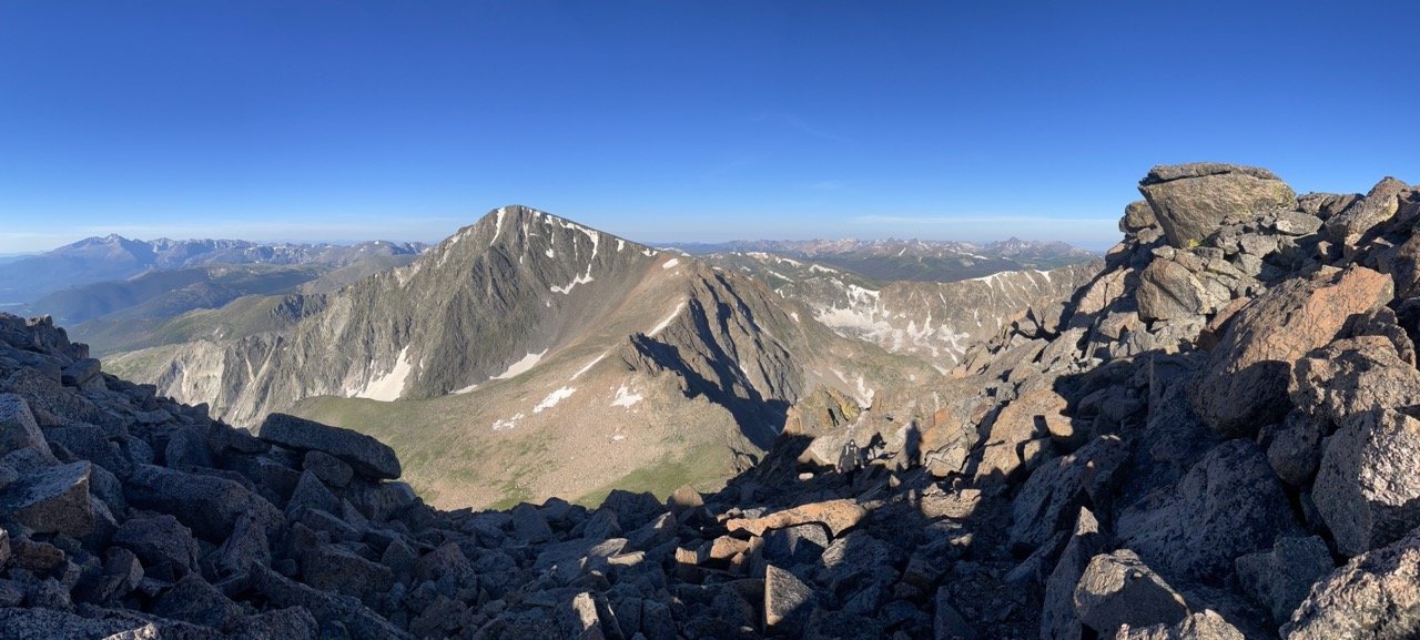
8:18 a.m. Fairchild Mountain- 13,502’ (Ypsilon Mountain in the background)
At the top of Fairchild Mountain, we know we are running behind some of our estimated time schedules. We get out quick communication to our contact, snack, hydrate, reflect on the 7 miles we have covered and try not to think too much about the 19 to go. Off the summit of Fairchild we skip, hop, jump, and move as best we can from rock to rock. The descent takes us down the North face of Fairchild, 1,200’, approximately 1 mile to a spot on the map labeled “The Saddle”.

There are pleasantries when the body is in use, tired, a little sore, but alive as ever. Training the body over many years to get to a point where you know exhaustion, what it feels like to push beyond, and test those limits. To put it to a test of endurance, repetitive movement, trusting that the hard work you have put in is for good reason and that you know you can keep going. A goal in mind. There is a finish line. Obstacles on a journey of this caliber though, push that finish line beyond any expected time result. Put the mind at ease, focus on one objective at a time. The finish will be there, it may just be dark by the time you arrive.

From “The Saddle” we gauge our route up the face of Hagues Peak. A little over 1,300’, and 1 mile, stand between us and the summit. Hagues is daunting standing below it, but we realize that once again the most direct route is up the South-West ridge. The boulders are bigger, the climb is steeper, and we shoot for a narrow “V” between the rocks hoping to grant us access to the summit. The Class 4 climbing towards the top takes some time and finally the route to the summit is revealed. Challenging climb, happy to reach the summit, we shoot another quick text to our contact. We also make a phone call to the Rocky Mountain National Park information office, to please pass along to the park ranger that all is well, but that we may be returning very late at night to pick up the Sprinter Van from Fall River Road.

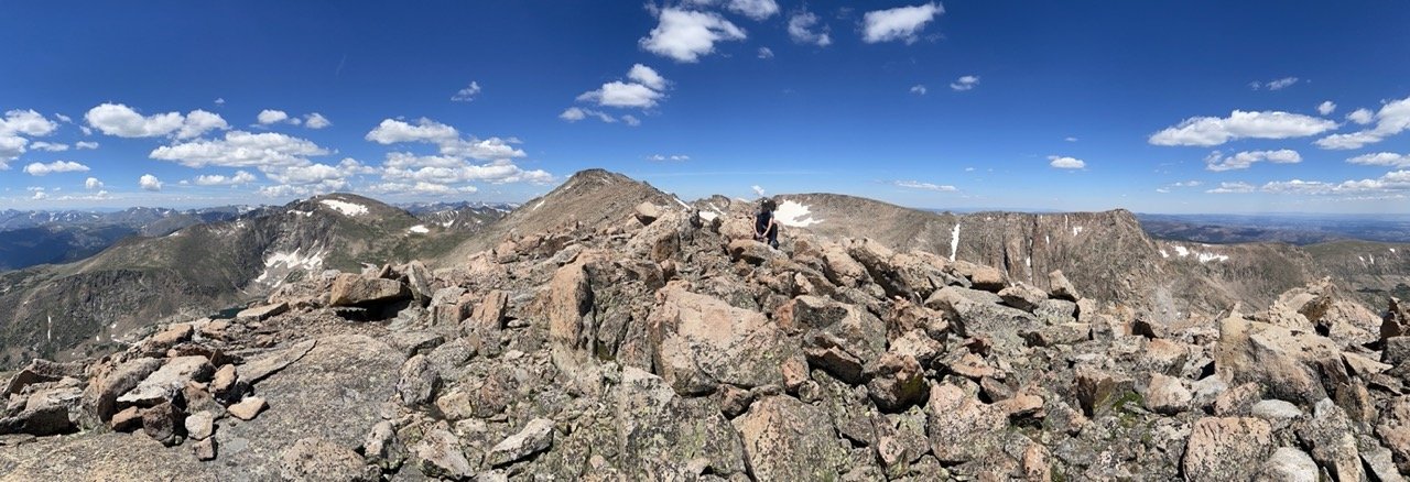
10:49 a.m. Hagues Peak 13,560’ (Fairchild and Ypsilon summits visible in the distance)
There is pause on a summit to take in the view, to realize the scale around you. Mountains so far in the distance, clear days make visible. Using the knowledge you have, marking locations and peaks. Sometimes you can see the path ahead, sometimes it is hidden from view. You know your time here is impermanent, you must keep moving and get back down, whichever way that is. What lies ahead? Planned route or adapt? Adaptation is key.

From the top of Hagues, Mummy Mountain is just down the ridge. Based on our travel time over the rocky terrain, we analyze that it is out of the question for today, so close, but a minimum 2 hour out and back to head over to Rowe Peak. Instead, we opt for a small unnamed peak that has an elevation of 13,301. It lies directly down the ridge towards Mummy but allows for us to return and drop down into the Rowe Glacier basin quicker. The terrain is rocky, boulders, ankle flexion, knees, legs still feeling solid, but it is slow moving.
11:30 a.m. Un-named Peak- 13,301’ (Hagues Peak center in the background, “The Saddle” and Fairchild to the left of it. Rowe Glacier basin and Rowe Peak to the right)
Endurance- “the fact or power of enduring or unpleasant or difficult process or situation without giving way.” Traveling, hours on end, the body grows tired, grows weary. The movement, the rocks, low steps, high steps, crouching movement, balancing on flat stones, sharp stones, feet resilient, body resilient. The mind wants you to think, “this is crazy”, “we should stop”, “this is no good” …you override the mind though, push the thoughts aside and move, just move. Fuel, food on regular intervals keeps the mind in check, water, hydration, cool comfortable temperatures at altitude, but warmer on descent. Hour after hour, this is the cycle, we will not give way!
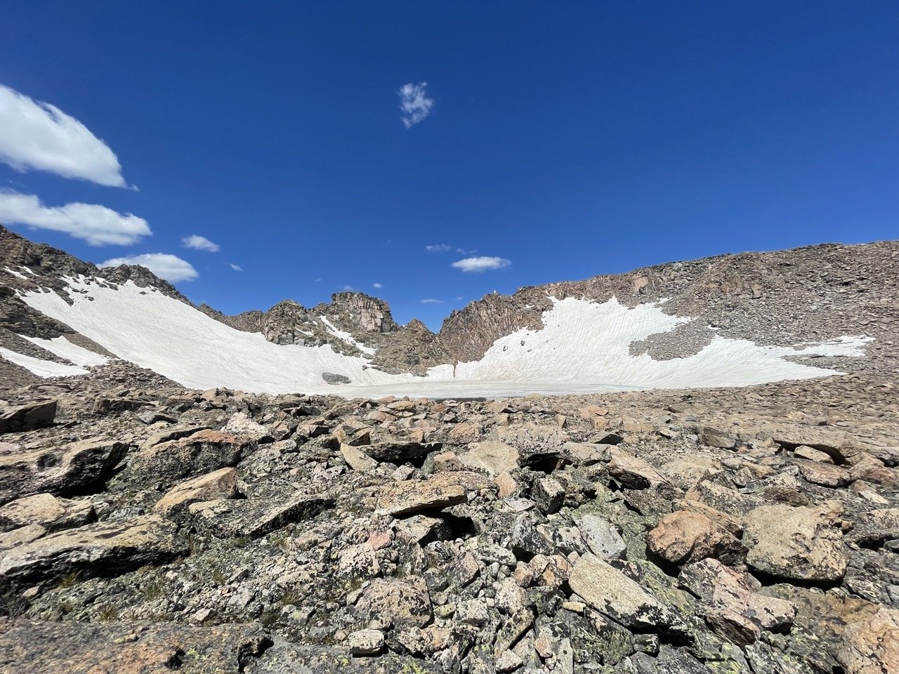
12:09 p.m. Rowe Glacier Basin
9 hours in, we descend 400’ into the Rowe Glacier Basin. The rocky terrain is starting to get to us, as the pace continues to slow because of it. We try to move as steadily through it as possible. We cross the basin and pick a route up the South-East face just east of the glacier, again direct seems to be the most logical. It’s a 500’ ascent up out of the basin to Rowe Peak. Gibralter Peak looms to the east, Rowe Mountain to the North. The timing it would take to go to Gibralter and back to Rowe Mountain we calculate adds too much time, and we abort that portion of the route and head straight for Rowe Mountain. This begins the descent that will lead us back to Dunraven.

12:37 p.m. Rowe Peak- 13,399’ (Rowe Glacier below, Hagues centered, Fairchild, and Ypsilon in the distance)
Distances and horizons obscured by different peaks and valleys; mileage doesn’t truly compute. Accompanied only by your climbing partner, there is no one else around, you have seen no one all day. The immensity of scale sets in, almost halfway through the route, still many hours to go.

The short descent to Rowe Mountain takes us down the North ridge from Rowe Peak. More rocky terrain to pick our way over and through. We are beginning to travel through a mix of rocks, grass, and snowfields. We stay high of the snowfields, and at around 1:15 reach Rowe Mountain- 13,183’. From Rowe Mountain we maneuver downward more, through slightly less rocky terrain, avoiding the small streams running from the melting snowfields. Methodically moving downward, keeping feet dry, continuous route finding. “Icefield Pass” as it’s called, is holding plenty of snow still this time of year. At one point we realize we must re-navigate back up and around one of the larger glaciers, as the runoff flows into a large stream that would be difficult to cross. It is cool to see that this stream is one of the larger tributaries that flows into the South Fork of the Cache la Poudre. In our re-route around the glacier we pop up onto the east ridge for a quick look over into the Lake Dunraven basin, that is fed from the Rowe Glacier, that ultimately feeds the North Fork of the Big Thompson. We descend from there another 800’ to “Icefield Pass” and then ascend a quick 200’ arriving around 3:20 p.m. at Skull Point -12,058’.

The land bridge of “Icefield Pass” in the middle of the picture. Rowe Peak up the mountain from the large glacier, and Rowe Mountain to the right of that. (Photo taken looking back from the ascent to Skull Point)
There is something magical about finding solitude in your own backyard, just you and your partner out there. We seek to find these spaces in a crowded world, refreshing that they still exist, we must go a little further each time though. Experiences and places that fill the soul in such ways, are not quickly forgotten, and only stronger are the relationships of those people who you share them with.

Looking down the North Fork of the Big Thompson. (Sugarloaf Mountain top left)
The scramble off Skull Point is the last of the big rocks for the day. The hike up to Sugarloaf Mountain is gradual and takes us up another couple hundred feet. It feels good to be hiking again at a quick pace, finding a good stride. We arrive at approximately 3:45 p.m. on the summit of Sugarloaf Mountain- 12,143’…our tenth and final peak for the day. We have traveled 15 miles so far and there are 11 to go. From Sugarloaf it is a gradual descent strolling through varied alpine meadow terrain, small drainages, mix of rock, faint trail, all crisscrossing our path as the wild still unfolds under us. We travel 2 miles down until we intersect the Stormy Peaks trail, at Stormy Peaks Pass. The first real trail we’ve had in almost 12 miles! We pause at this junction, snack, hydrate, finishing the 4 liters of water we have carried with us up to now. It is 5:00 p.m. 14 hours of moving up to this point, and 9 miles to go. The motivation is high now to reach that finish line, the pace down the trail is quick, stopping only to filter another 2 liters of water, and drink when needed. 3 miles down the trails and switchbacks of the Stormy Peaks trail we intersect the North Fork Trail. The last 6 miles are crushed at a pace neither one of us has hiked at before. Focused solely on moving the body down the trail, portions of the trail that are familiar are almost blocked out, passing them is hard to remember. The body is tired, but it is moving well. We arrive at the Dunraven trailhead at 8:30 p.m., the marathon is complete, the sprinter van retrieval remains and will take us an additional 3 hours, but there is magic in that as well.

Food and cold hydration stored in the cooler in the car at the trailhead, taste incredible. The remaining hours of the day deliver a family of bears outside Glen Haven, deer near Lumpy Ridge, and an astounding heard of elk at the top of Fall River Road once we have retrieved the Sprinter Van. The only wildlife we have seen all day besides the occasional marmot or pika. It is midnight when we arrive back at home in Fort Collins, quick unpack, shower, good night once again!
